காவிரி டெல்டாவில் குடிமக்கள் அறிவியல் இணைவு
The Cauvery delta is located at the mouth of the 80,000 sq. km Cauvery river basin. Cauvery river, which has its origins in the high elevation, biodiversity-rich Western Ghats, flows through a semi-arid, hot plateau before reaching the delta ( area of nearly 7500 sq. km), which is slightly wetter. While the upstream areas get rainfall from the south-west monsoon between June and September, the delta gets most of its rainfall from the north-east monsoon from October to December, via intense cyclonic storms.
The canal irrigation system in the delta began with the construction of the Grand Anicut by the Chola king at the mouth of the delta. It remains one of the oldest water regulation structures in the world, still in use. Canal irrigation allowed a system of intensive paddy cultivation (often 3 harvests) along with the collapsing system of traditional water harvesting tank-structures.
Today, the Cauvery delta is under increasing human and natural pressure. Both global and local change drivers with intensifying human activity, increasing climatic extremes, changing river flow regimes and sea-level rise, have put the delta and the population it supports at increasing risk. Over time, the construction of dozens of large dams upstream has resulted in the decline of streamflow as well as sediment delivery. As surface flows declined, groundwater pumping increased resulting in declining base flows and saltwater intrusion along the coast. At the same time, increasing the frequency of intense cyclones has increased flood risks.
The research project 'Pathways towards a sustainable and inclusive Cauvery Delta' is being undertaken in the Cauvery Delta region in the state of Tamil Nadu, Southern India. Through this project, the team seeks to understand the interactions between humans, the engineered and the natural systems and identify possible main trajectories and their tipping points.
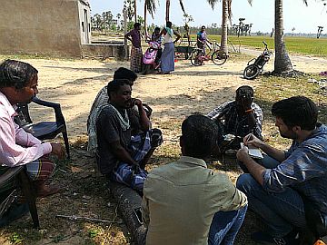
As a part of this project, the Citizen Science Campaign Program has been planned to understand the changes in the ground water depth and salinity across the Cauvery delta districts. The Citizen Science Program is a participatory research engagement involving farmers, school & college going students, youth groups and any people residing and having knowledge about delta.
The data collected will be available in the form of a dashboard, which will be available as open data for the public. This will also be of great use for the people involved in the decision making process in the delta.
காவிரி டெல்டா என்பது 80,000 சதுர கி.மீ காவிரி நதி படுகையின் முகப்பில் அமைந்துள்ளது. உயரமான, பல்லுயிர் நிறைந்த மேற்குத் தொடர்ச்சி மலைகளில் அதன் தோற்றத்தைக் கொண்டிருந்தாலும் காவிரி நதியானது, (கிட்டத்தட்ட 7500 சதுர கி.மீ பரப்பளவு)அரை ஈரமான, சூடான பீடபூமி வழியாக ஓடுகிறது. ஜூன் மற்றும் செப்டம்பர் மாதங்களுக்கு இடையில் காவிரி மேல்நிலை (upstream) பகுதிகளில் தென்மேற்கு பருவமழை பெய்யும். ஆனால், காவிரி டெல்டா பகுதியானது அக்டோபர் முதல் டிசம்பர் வரை வடகிழக்கு பருவமழை மூலம் கடுமையான சூறாவளி புயல்கள் வழியாக மழையைப் பெறுகிறது.
காவிரி டெல்டா பகுதியில் உள்ள கால்வாய் பாசன முறையானது, டெல்டாவின் முகப்பில் சோழ மன்னரால் கல்லணை கட்டுமானத்துடன் தொடங்கியது. இது இன்னும் பயன்பாட்டில் உள்ள உலகின் பழமையான நீர் ஒழுங்குமுறை கட்டமைப்புகளில் ஒன்றாக உள்ளது. கால்வாய் பாசனமானது பாரம்பரிய ஏரி நீர் சேகரிப்பு கட்டமைப்புகளின் உதவியுடன் தீவிரமான நெல் சாகுபடி (பெரும்பாலும் 3 அறுவடைகள்) முறையை அனுமதித்தது.
இன்று, காவிரி டெல்டா பகுதியில் மனித மற்றும் இயற்கை அழுத்தங்கள் அதிகரித்து வருகிறது. மனித செயல்பாடுகள் தீவிரமடைதல், தட்பவெப்ப நிலை அதிகரித்தல், நதிநீர் ஓட்டத்தில் மாற்றங்கள் மற்றும் கடல்நீர் மட்டம் உயர்தல் போன்ற உலகளாவிய மற்றும் உள்ளூர் மாற்ற இயக்கிகள் டெல்டாவையும் அதன் மக்களையும் பாதிக்கும் அபாயத்தை கொண்டுள்ளன. காலப்போக்கில், டஜன் கணக்கான பெரிய அணைகளை மேல்நிலை பகுதியில் (upstream) கட்டியதன் விளைவாக நீரோட்டம் மற்றும் வண்டல் மண் வரத்திலும் குறைவு ஏற்பட்டுள்ளது.
நிலத்தின் மேற்பரப்பு நீரோட்டம் (surface flow) குறைந்துவிட்டதால், நிலத்தடி நீர் சார்பு(pumping) அதிகரித்து, இதன் விளைவாக நிலத்தடி நீர் ஓட்டம் குறைந்து, கடல்நீர் ஊடுருவல் கரையோரத்தில் அதிகரித்து காணப்படுகிறது. அதே நேரத்தில், தீவிர புயல்கள் நிகழும் வீதமும் அதிகரித்து வெள்ள அபாயங்களை அதிகரித்துள்ளது.
தமிழ்நாட்டில் உள்ள காவிரி டெல்டா பகுதிகளில் ‘'Pathways towards a sustainable and inclusive Cauvery Delta’ என்ற ஆய்வு மேற்கொள்ளப்படுகிறது. இந்த ஆய்வின் மூலம், மனிதர்கள், வடிவமைக்கப்பட்ட கட்டுமானங்கள் மற்றும் இயற்கை அமைப்புகளுக்கு இடையிலான தொடர்புகளைப் புரிந்துகொள்வதற்கும் மற்றும் சாத்தியமான முக்கிய பாதைகளையும் (main trajectories) அவற்றின் முனைப்புள்ளிகளையும் (tipping points) அடையாளம் காண ஆய்வுக்குழு முயற்சிக்கிறது.
இந்த ஆய்வின் ஒரு பகுதியாக, காவிரி டெல்டா மாவட்டங்களில் நிலத்தடி நீரின் ஆழம் மற்றும் உப்புத்தன்மை ஆகியவற்றில் ஏற்பட்ட மாற்றங்களை புரிந்து கொள்ள மக்கள் அறிவியல் திட்டம் (Citizen Science Program) திட்டமிடப்பட்டுள்ளது. மக்கள் அறிவியல் திட்டம் என்பது விவசாயிகள், பள்ளி மற்றும் கல்லூரிக்குச் செல்லும் மாணவர்கள், இளைஞர் குழுக்கள், டெல்டாவில் வசிக்கும் மற்றும் டெல்ட்டாவை பற்றி புரிதல் உள்ளவர்கள் அனைவரையும் ஈடுபடுத்தும் பங்கேற்பு ஆராய்ச்சி (participatory research) முறையாகும்.. சேகரிக்கப்பட்ட டேட்டா (data) தரவுகள் பொதுமக்களுக்கு திறந்த தரவுகளாக (open access) இணைய தளத்தில் டாஷ்போர்டு (dashboard) வடிவத்தில் கிடைக்கப்பெறும். மேலும் இது டெல்டா பகுதி குறித்து முடிவெடுக்கும் பணியில் ஈடுபடும் நபர்களுக்கு, மிகவும் பயனுள்ளதாக இருக்கும்.
